Updated: 2/20/2026
- UPDATE: Mt Tom is now a P4 site, or P3 site with Observer.
Mount Tom is an NEPHC managed flying site that is located in the Mount Tom Massachusetts State Reservation. However, the launch and landing areas are located on private property. Through careful negotiation, NEPHC has been allowed use of the launch and landing areas, and as such, pilots do not have the “right to fly” there. NEPHC club members, have the privilege to fly there. We must follow both the NEPHC and USHPA operation and safety guidelines to keep this privilege.
The site has both a primary Northwest and an alternate West-Southwest launch. It has a very steep cliff face that needs to be respected. Both launches can be tricky for new pilots. The landing area is large with good approaches, but has several areas to watch out for; A horse paddock, nearby neighbors houses and power lines at the Eastern end of the LZ.
The takeoff is at 1150ft MSL, the landing area (LZ) is 200ft MSL (950ft vertical). As a low ridge it can be flown when other sites are blown out, but due to potential thermal mixing, it is susceptible to gusty winds when upper-level winds are higher. When the conditions are right, it is just an amazing place to fly!

Historic Postcard of the Top of Mt. Tom
- Flight Type: Ridge and Thermals with XC potential. Excellent “Wonder-wind” at the end of the soaring day.
- Required: valid current USHPA and NEPHC memberships
- USHPA Rating Requirement: P4 (no P3 launches without an Observer)
- Wind direction: Launch 1: WNW (Ideal: 290-310 degrees, OK: 270-330), Launch 2: WSW(Ideal: 220-240 degrees, OK 215-245)
- Wind speed (PG):
- 6-8 mph minimum
- 10 mph ideal
- 15 mph maximum – do not launch a standard sized paraglider in wind exceeding 15 mph, unless you are certain you have the skill, experience and your glider can penetrate. Mini wing operating limitations are at the pilot’s discretion.
- +5 mph maximum gusting (mini wing)
- Make certain you check the forecasted winds at higher altitudes (3000ft to 6000ft) before planning to fly.
- Wind speed (HG):
- 8-10 mph minimum
- 15 mph ideal
- 20 mph maximum – depends on experience and skill of the pilot
- +5 mph maximum gusting
- Make certain you check the forecasted winds at higher altitudes (3000ft to 6000ft) before planning to fly.
General Overview of the Mt Tom site
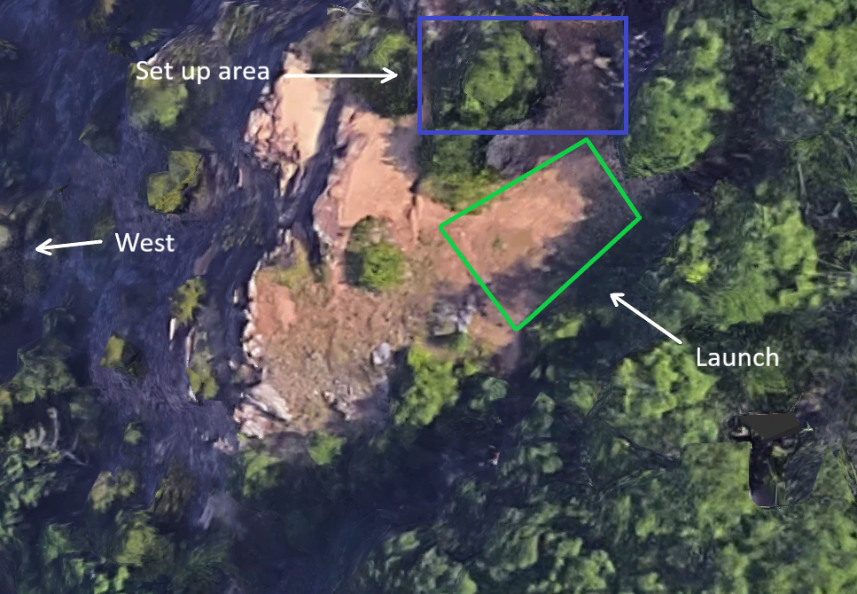
- Launches: The launch areas on Mt. Tom are located on private property — not Massachusetts State Park property. We are permitted to utilize this private land only if members adhere to the USHPA safety guidelines and FAA regulations that govern Part 103 flight. The launch areas are small and rocky; forward launches are not possible.
Generally, please politely ask any spectators to stand at least 30ft. away (especially downwind of launch). Specifically, request that spectators come up behind launch and off the trail near the cliff face.- Launch Elevation: 1150ft (350m)
- Launch 1 (WNW) : 42.242079, -72.647993. West-Northwest facing cliff launch.
- Launch 2 (WSW): 42.242403, -72.648304 West-Southwest facing cliff launch.
- Min Req Glide Ratio to LZ: ~1.1:1
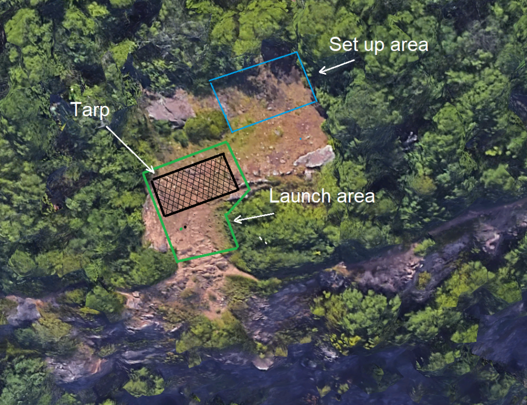
Main Launch (NW) and set up area
Alternate Launch (WSW) and set up area
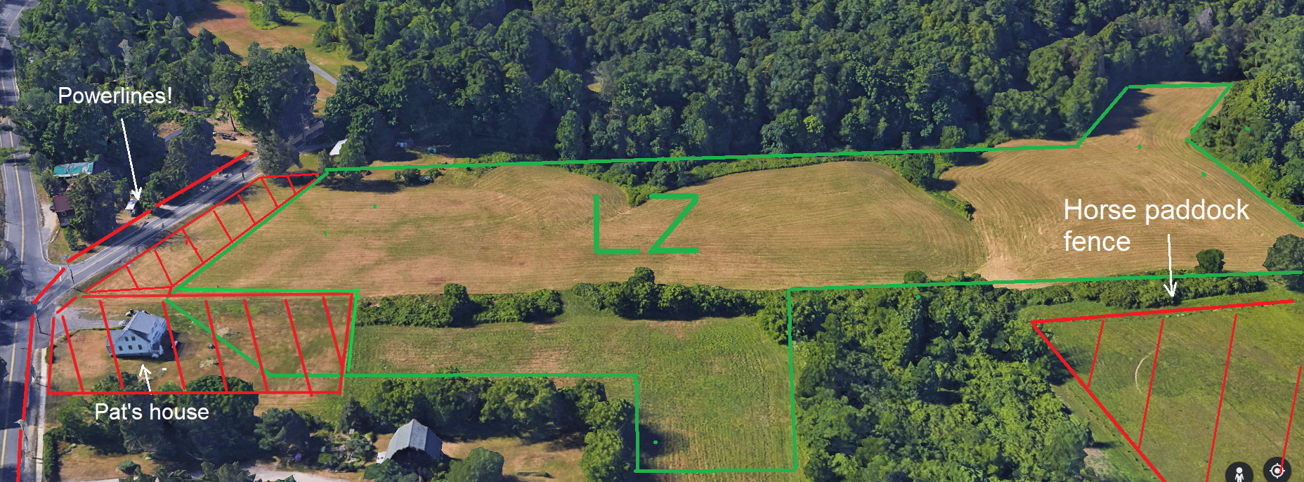
- Main Landing Zone: 42.249534, -72.654258.
- There are several very good approaches to landing at the LZ, as can be seen in the image below. It is best practice to arrive high and fly to the west of the LZ and do either a standard pattern to land or a classic figure 8 descent keeping away from the power lines on the east end of the LZ, highlighted below in red. The large bushes located just below ‘LZ’ in the image have now been cut down which increased the usable area and allows an easier approach to the South.
- This field can be closed in the Summer for tall hay. All pilots should avoid flying too close to horses in the paddock shown in the LZ image and nearby and houses. Do not land in the horse paddock. After landing, stay off the area highlighted below in red near the house. The property formerly known as “Pats” this includes the driveway, the former breakdown area near the house and the L shaped North-South approach.
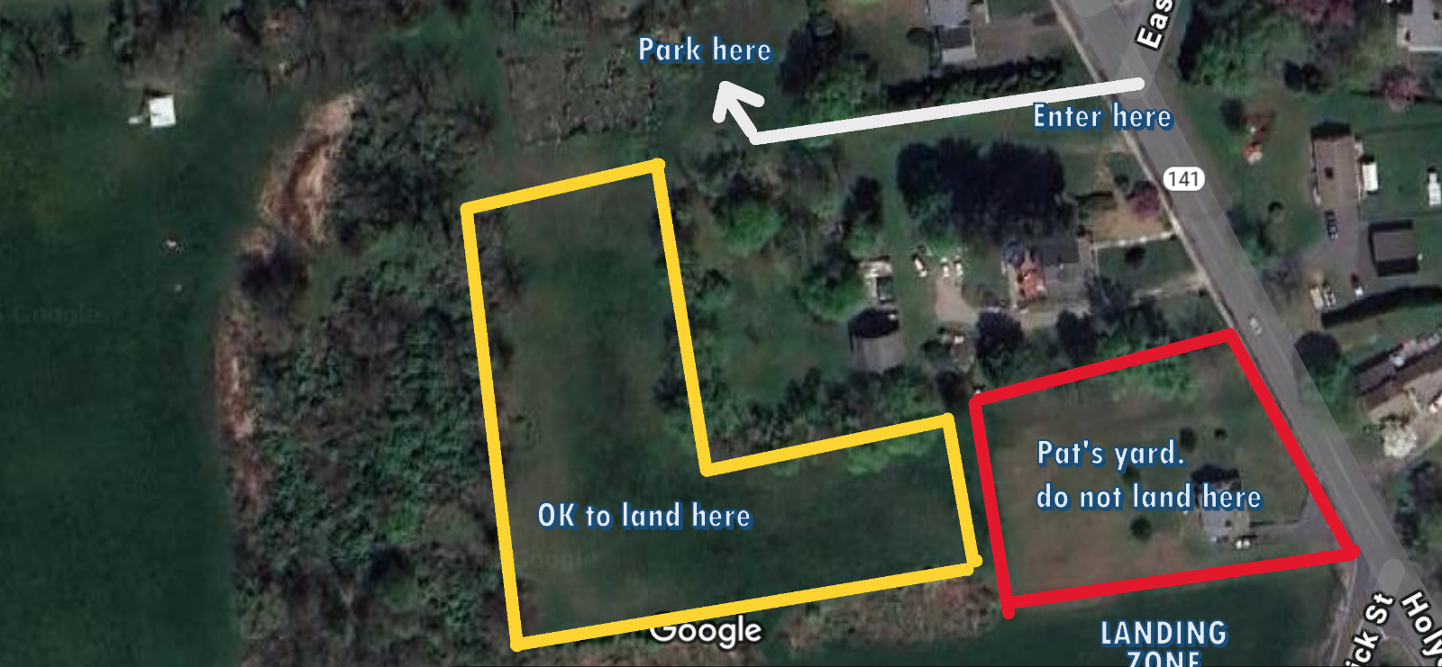
Part of the LZ and access to parking as viewed from the South
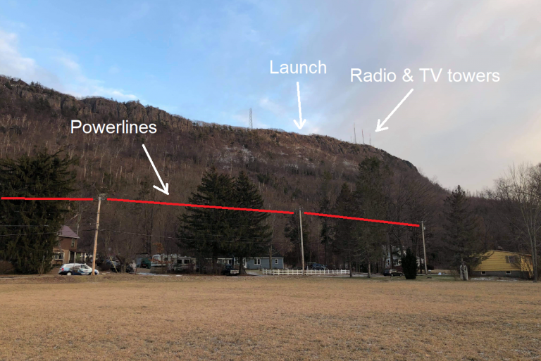
Launch, the end of the ridge and TV towers as seen from the LZ
- Airspace: This site has restricted airspace behind launch (Westover AFB) and to the South West of the field (Barnes Airport). Occasional low flying aircraft (C5 Galaxy, C-130 and F-35 fighters!) in the area. Before flying XC check an FAA sectional map for the airspace information.
- Hazards: Steep rock cliff, TV/Microwave towers to the South of launch, other misc. towers to the North on the ridge, power lines in the landing area (as shown in the image above).
- Best time to fly: Year-Round! However, at the end of November the tarps to make launching easier are typically put away.
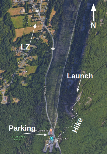
- Vehicle Access: None. Hike to launch only.
- Parking for hike up: 42.236676, -72.651627. This is the Log Cabin Restaurant parking lot, address is 500 East Hampton Rd, Holyoke, MA.
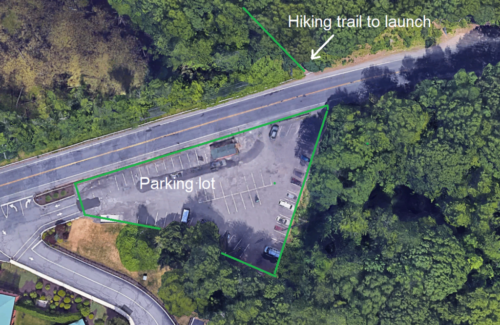
Parking area (Log Cabin Restaurant)
Rules and Regulations
- Mt Tom is a P4 site. P3 pilots must be have an Observer to fly. To get a site introduction from a qualified club member. See the Mentor list and check social media, FB and get on the Mt. Tom WhatsApp group for contacts.
- Land only on the designated landing area.
- Tandem flights are only to be used for training purposes and must be done only by USHPA rated Tandem Instructor pilots. No commercial operations are allowed!
- Respect the private owners and neighbors of the LZ area. Minimize disturbing the kind people that allow us to use their property. No alcoholic beverages. Pack up quickly and quietly and leave the area.
- Remember: the launch is an environmentally sensitive area. We are guests of Holyoke and Easthampton and fly there only because of their generosity and support!
Safety
- Always follow USHPA Safety guidelines.
- Launching at Mt Tom requires top-notch kiting skills. The rotor frequently makes launching very challenging. Do not bring a new wing there without extensive ground handling practice. More than one pilot has been surprised by getting plucked off unexpectedly!
- Never fly alone. Use the “Buddy System” to check each pilot’s harness attachment and parachute pins before launch.
- Always have your speed system connected.
- Stay clear of the launch area when others are trying to launch, keep spectators back and behind the launch area.
- Check winds aloft as well as monitoring surface wind forecast. Be aware of launching into building (increasing wind) conditions.
- Use a GPS equipped variometer to monitor your ground speed into the wind.
- Avoid flying too far back (east) of the ridge, there is always a danger of getting blown back or a tree landing.
- The area to east of the ridge is restricted airspace.
- Watch out for the powerlines at the East end of the landing area. Never try to squeak over the powerlines!
- Unless you are very low on an East final approach always land away from the powerlines.
- Staying on the ridge too long while sinking out can make it hard to get to the landing area. Make sure you leave the ridge early with adequate altitude for a safe pattern and landing.
- Stay well clear of the radio, TV and microwave towers to the South of launch and the wind turbine towers to the North.
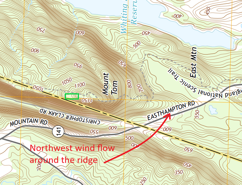
- Be careful of flying too far South past the TV and microwave towers in a Northwest crosswind. Due to the topography (see topographic contour image below) you can find yourself having trouble penetrating upwind from the wind sweeping around the bluff corner at the end of the ridge. Pilots have had tree landings in the past making this rookie error.

- Don’t fly too close to the ridge in light conditions while scratching to stay up. It’s a solid rock cliff face!
- Don’t fly low over the neighbor’s houses near the LZ.
- Be aware that at the end of the day, the wind can blow katabatic (downhill from the East). Check the wind sock and streamers in the LZ while on approach.
- Be familiar with the NEPHC Emergency Action plan .